
Public Access Birding Sites in Putnam County, Tennessee
If you have information about other public access birding sites in this county, please send details to me at this e-mail address:
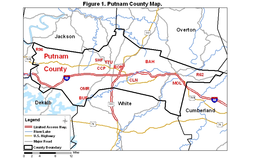
Putnam County covers an area of 1042 km2 (402.5 mi2). A map of the county—with the some sites noted below coded on it—is available via the following link:
Burgess Falls State Park, formerly Burgess Falls State Natural Area (BUF), part of the Tennessee state parks system, is located about eight miles south of I-40 (exit 286) on Rt. 135 (Burgess Falls Rd.). The park (Figure 1—not yet complete) features several waterfalls near a half-mile-long trail, culminating in an overlook of Burgess Falls; this70-foot waterfall is among the most scenic falls in the Upper Cumberland Region. The park opens at 8:00 AM each day and closes at sunset.
Birding along the trail by the Falling Water River is often limited by water noise created by the various falls. A gravel road also leads to Burgess Falls and is often better for birding than the trail. The area between the dam and Middle Falls often harbors a pair of Yellow-crowned Night-Herons between mid-April and mid-September. Acadian Flycatchers and Louisiana Waterthrushes are regular summer residents along the hemlock-dominated river trail.
Birding the lake impounded by the dam in the park can be good for herons in late summer and ducks in winter. Use great care if you bird from the bridge on Rt. 135. The lake can also be birded along a poorly maintained trail; get to this trail by driving southeast from the bridge on Rt. 135 about one-third of a mile to the first road on the left; take this road a short way to a bridge over a creek and park at the first dirt lane on the left past the bridge; walk the dirt road/trail for about half a mile.
A check-list of species sighted in the park is available at this website.
In 2014 an addition to the park was purchased—Window Cliffs State Natural Area. Located at the end of a road that branches off from the intersection of Old Mill Rd. and Ball Hill Rd. (either of these roads is accessible from Cookeville Boatdock Rd., which is accessible itself from Burgess Falls Rd.), this addition to the park offers access to scenic parts of Cane Creek to the north of the main park. A somewhat rugged trail with water crossings leads to the "windows." This trail is 2.5 miles one-way.
Cane Creek Park (CCP), located in west Cookeville, is a municipal park of about 200 acres including a 56-acre lake created by impounding Cane Creek. Find the park by driving north on Willow Avenue off of I-40 (exit 286) about 1.5 miles to West Jackson; go left on West Jackson about a mile to Buffalo Valley Rd.; go left on Buffalo Valley about half a mile to CC Camp Rd. on right; take CC Camp Rd. about a half mile to the park entrance on the left. The park opens at 7:00 AM on most days of the year, but it is closed on some holidays.
|
|
| Cane Creek Park lake viewed from the south shore with some American White Pelicans visible. Photo Credit: Stephen J. Stedman 12 November 2017. |
The park bird check-list includes 218 of the 262 species known to have occurred in Putnam Co. (as of November 2018). Birding is fair to good during all seasons of the year. There is a 2-mile loop trail (Figure 1) around the lake that wanders through a variety of habitats. Along the northeast edge of the lake, excellent habitat for Willow Flycatcher prevails, and a pair of these flycatchers was present during all breeding seasons from 1999 to 2004. The lake usually draws in a few ducks each winter; during November–December 2000 a Long-tailed Duck stayed on the lake about a month; another was seen for a few days during May 2002; and still another was present December 2003–February 2004. Note: in recent years, the park personnel have been clearing underbrush and shrubby areas of the park at a fast pace, destroying these places as wildlife habitat in the process; anyone with influence with the Leisure Services director or with the park personnel is encouraged to speak with them about the ignorance of their cosmetic approach to park maintenance. If you wish to speak out about this issue, you may access the Leisure Services website—where you can find email links for various personnel, including the director, Rick Woods, who blocked a link to that site from this site.
Ensor Sink Natural Area is located near South Jefferson Ave. about a mile and a half north of I-40 (exit 287). From the interstate, go north on Jefferson to West Jackson and go left about a block to the first street (Foutch) on the left; take this street about 0.2 mi to the first left (Clover Hill Rd.) and go left about 200 feet to the entrance to the park, also on the left. The park opens at 7:00 A.M.
This park features a short (0.3-miles long) loop trail that goes by Ensor Sink. About 105 species have been recorded in the park (as of December 2004), but this list will grow as more birders spend time there. A checklist of the birds of Ensor Sink may be viewed by clicking on the red word at the beginning of this sentence.
Walnut Park (Figure 1) is a small municipal site near downtown Cookeville. It may be accessed from South Walnut Avenue about one block south of Spring Street (Rt. 70N) on the east side of South Walnut. Look for the Cookeville Senior Citizens Center, pull in behind it, and park. Then walk around the short (0.15-mi long) loop trail in the picnic area. The brushy area on the north side of the picnic area has been the most productive part of the park to check for birds. About 95 species of birds have been reported from this site (as of December 2007). A checklist of the birds of Walnut Park may be viewed by clicking on the red word at the beginning of this sentence.
City Lake Natural Area (CLN—Figure 1 is located just off I-40 (exit 290). From the exit ramp on the south side of the interstate, go south 0.2 miles to Poplar Grove Rd. on the left; Bridgeway Rd. connects to Poplar Grove Rd. almost immediately on the right; take Bridgeway downhill about 0.4 miles to the entrance to the park on the left just before the bridge over City Lake. The park opens at 7:00 A.M.
A short (0.4-mi long) trail to a small waterfall offers woodland birding opportunities, while a boat ramp and fishing dock offer views of the lake, which is an impoundment of the Falling Water River. Nearly 200 species of birds have been recorded in a yard almost immediately adjacent to the natural area (as of March 2020); most of these have probably also occurred within the park.
The Merle Osborn Nature Preserve is a new (in 2007) public access birding site in the county; currently, access is limited to those who gain permission from Tennessee Parks and Greenways Foundation personnel, but at some point the preserve will be open to the public. Accessible via either Fox Knob Rd. or Victory View Rd., this forested preserve was recently donated to the county by Merle and Ruth Osborn. Access the western portion of the preserve from Rt. 70N by traveling east from I-40 toward Monterey about 10 km (6 mi) and turning left on Shady Lane about a km (0.5 mi) before Rt. 70N begins to climb the escarpment to the Hartselle Bench of the Cumberland Plateau; take Shady Lane about 2 km (1.3 mi) to Victory View Rd. on left, take Victory View about 2.5 km (1.5 mi) to its end, where Fox Knob Rd. goes off to the right; look for a preserve sign on the left where a log road leads downhill about 1 km (0.5 mi). Alternately, take Poplar Grove Rd. east from Rt. 70N just south of the I-40 intersection with Rt. 70N; follow Poplar Grove Rd. about 2.5 km (1.5 mi) to the bridge over the Falling Water River; turn right onto Rocky Point Rd. and follow it about 3 km (1.7 mi) to Victory View Rd. on the right; take Victory View to a point about 100 m past a very small wood plank "bridge" over a creek and park on the right at a field access point; the same log road that leads down from Fox Knob Rd. ends here. The eastern portion of the preserve is more difficult of access and should only be accessed with someone who knows the log roads of that area and how to get to them.
Shipley Farm (SHF) and the Hyder-Burks Pavilion, operated by Tennessee Technological University, are located on Gainesboro Grade about 2.5 mi west of the intersection of 12th St. (which becomes Gainesboro Grade to the west) and Willow Ave. Most of the farm is not accessible without obtaining permission, but the old trees near the picnic area on the right as you enter the property may be birded without having to obtain permission; Red-headed Woodpeckers are sometimes found there, depending on the quality of the nut crop and on the degree of removal of dead trees and limbs that has been undertaken. The road leading to and around the pavilion is also open to the public and may be birded at any time. Birds of open country may be found to the west this area.
The Happy Hollow Boat Ramp on the Caney Fork River at the DeKalb County line is a good place to check if you are going to Edgar Evins State Park or Center Hill Dam in DeKalb County. This boat ramp may be accessed from I-40 (exit 268). From the exit go south on Rt. 96 a little more than a mile, crossing a RR track in an uphill grade and approaching the parking lot (on the right hand side of the road) to the boat ramp near the end of the ensuing downhill grade; if you pass the county line, you have gone too far. Park in the lot and walk down the ramp to river level. If there is no release water from Center Hill Dam, the gravel flats in the river bed are exposed and you may walk and wade (bring waterproof boots or take off your shoes) upstream quite a ways or downstream a hundred yards or so, searching for shorebirds, herons, and ducks, and listening for songbirds. If there is a release from the dam, the water is too deep and fast to allow access without a boat. The river may be canoed from the dam to Happy Hollow (and on to the I-40 rest stop at mile 267 on I-40, to Betty's Island in Smith County, about three miles downstream, and even further to the confluence with the Cumberland River).
Please send details about any birds you record in these parks—or any public access site in Putnam Co.—to me at the e-mail address noted above. sjs.
Quick links to other sections of this website: